The Roman Amber Road from the Adriatic to the Danube region
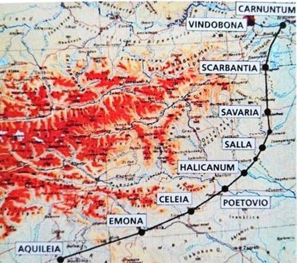
The Amber Road follows a prehistoric trade route that was in use since the early Bronze Age, was frequently rerouted, and was provided with milestones, as, for instance, under Emperor Hadrian in 132 AD and later under Emperor Volusianus (251 to 253 AD). In its importance as a north-south transport connection between the Baltic Sea and the Adriatic, it can be compared to a modern motorway (EU Transversale). Many current new transport route plans (road and rail projects) in Europe (e.g. the A3 motorway, the Southeast Span) are based on the Roman Amber Road.
Emperor Augustus had the pass road built over the Julian Alps (Birnbaum Saddle/Birnbaum Forest). Under Tiberius, the road from Emona/Ljubljana to the Danube was reconstructed as a military road with gravel embankments, road ditches, wooden and stone bridges, and cart tracks partially hewn into limestone.
The Amber Road was a via publica, an imperial and postal road, and a military and trade route. Between the towns which developed from military camps, road stations (mansions, mutations) grew up with inns and horse-changing stations for the imperial post (cursus publicus). These road stations, the towns, important river crossings, and mountain passes were recorded on maps and in travel books. The most famous ancient road map is the Tabula Peutingeriana, which is kept in the Austrian National Library.
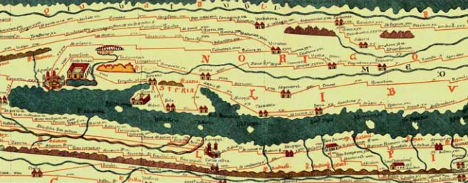
Fig.: Detail of Tabula Peutingeriana
Source: Austrian National Library, Manuscript Collection Cod. 324
The name Amber Road is not antique, but dates back to the last century based on a report by the Roman writer Plinius the Elder, who reports that amber was transported along this route from the Baltic coast via Carnuntum to Aquilea, the centre of the amber trade. He furthermore reports that the Germanic coast where amber is collected is 600 miles (880 km) from Carnuntum.
Amber, the “Gold of the Baltic Sea”, is a fossilized, honey-yellow to reddish-brown resin, which is between 25 and 50 million years old. It comes from the resin of conifers which had sunk into deep layers of sediment due to water, ice, and breaking of waves. There they were covered by sand, dust, new rock layers, or water, and turned into amber under the influence of air and pressure. The finds often show inclusions of prehistoric insects or plants. Amber had been popular as jewellery (pendants, necklaces, rings, small figurines, etc.) since the 3rd millennium BC and was also in great demand as expensive bling jewellery in early imperial Rome. Amber was also used in magic and healing, and also as incense material.
Extensive trade already existed in the Bronze Age (2000 to 800 BC). In Roman times, Carnuntum and Aquileia developed into centres of amber trade. During the reign of Emperor Augustus (27 BC to 14 AD), amber was transported from the Baltic coast through Germanic territory to Carnuntum and along the Roman Amber Road to Aquileia on the upper Adriatic for further processing. Amber grinding workshops existed in Carnuntum and Aquileia. In the Carnuntum area, the Amber Road crossed the River Danube as a long-distance trade route, making Carnuntum an important trading centre. The Amber Road north of the River Danube was not a paved road, but rather a series of routes leading south from the Baltic Sea. One of the most frequented trade routes led across the Vistula (Weichsel River) to the Moravian Gate and followed the Morava (March River) to its confluence with the River Danube. This route is documented by numerous amber finds. A particularly beautiful piece of amber jewellery, also from the central Burgenland section of the route, is on display in the Burgenland Provincial Museum (Burgenländisches Landesmuseum).
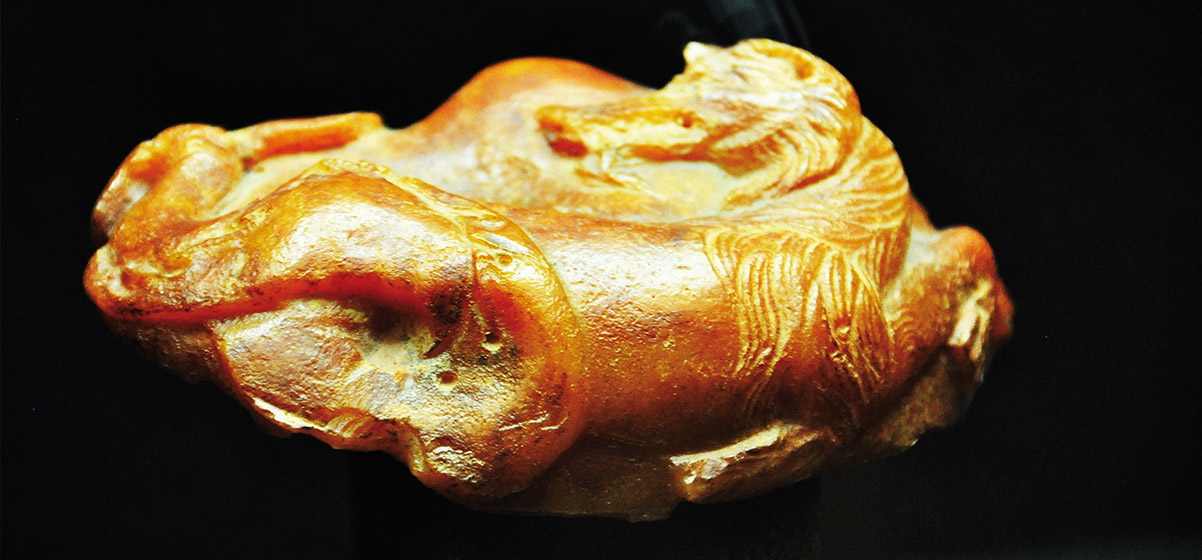
Fig.: Mythical creature with a wolf’s head and fish tail as amber jewellery (Roman, 2nd century AD, found in Girm)
South of the River Danube, the Amber Road was integrated into the Roman road network running through what is now Lower Austria, northern and central Burgenland, western Hungary, and Slovenia to northern Italy ending at the important port of Aquileia (Grado). Of all the goods transported on the Amber Road (iron, wine, ceramics, glass), raw amber certainly accounted for the smallest share. Nevertheless, the highly desired gemstone gave its name to the entire trade route.
Schaupult Nebersdorf: Römischer Straßenbau
Schaupult Strebersdorf: Handel und Reisen in römischer Zeit
Schaupult Horitschon: Industrie und Handel
- August, Ernst: Geschichte des Burgenlandes, Verlag für Geschichte und Politik, Wien 1987, S.11 – 19
- Gruber, Andreas: 25 Jahre Verein zur Erhaltung der Bernsteinstraße 1989 – 2014, Festschrift zum 25-jährigen Jubiläum, S. 11 und S. 28f.
- Gruber, Oswald, 25 Jahre Verein zur Erhaltung der Bernsteinstraße 1989 – 2014, Festschrift zum 25-jährigen Jubiläum.
- Kaus, Karl: Die römische Bernsteinstraße Carnuntum – Aquilea. Exkursionsführer, Schriftenreihe Allgemeinbildende Höhere Schule 2/1999 des Pädagogischen Institutes Burgenland.
Landesmuseum Burgenland: Die Bernsteinstraße. Evolution einer Handelsroute. Wissenschaftliche Arbeiten aus dem Burgenland (WAB), Heft 123. Eisenstadt 2008.


