The Roman Amber Road in Central Burgenland
Coming from Savaria (Szombathely) it runs right through the district of Oberpullendorf and leads to Scarbantia (Sopron).
Survey
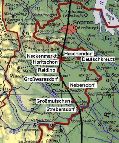
The Roman Amber Road from Savaria(Szombathely/Steinamanger) to Scarbantia (Sopron/Ödenburg) runs through the district of Oberpullendorf. The trail comes from Köszeg to Klostermarienberg, crosses the Stooberbach near Frankenau, and then leads along the western banks of the tiny river Raidingbach to the village forest of Großmutschen, where this causeway has been protected since 1931as a place of historic interest.
It continues its way via Nebersdorf and Großwarasdorf to Raiding, where there is a sharp bend to the east in the direction of Horitschon. From there it leads to the Hungarian border and to Scarbantia (Sopron/Ödenburg). Even today the ancient trail can still be detected clearly in the countryside. Due to modern constructional and agricultural activities some parts of the trail have been destroyed, however.
In order to make this unique historical monument accessible to visitors of the thermal spa of Lutzmannsburg and to bikers in the area of central Burgenland, which is called Sonnenland Burgenland, the Association for the Preservation of the Ancient Roman Amber Road expanded the ancient trade and transport route into a hiking trail and already in 1988 set up information boards on important topics of Roman history in between Strebersdorf and Deutschkreutz.
These information boards made of ceramic tiles were designed and hand-painted by the Oberpullendorf artist Romana Schmucker with detailed drawings about the Roman times and in the three vernacular languages German, Croatian, and Hungarian. In addition to that they established Roman milestones and tombstones with pictures of carts. In 2003 the hiking trail was turned into Cycle Track B47 – Roman Amber Road and additional information boards were set up.
The following historic topics can be retrieved here or via QR-code at the individual presentation boards:
- The Roman Empire and Roman Emperors (information board Raiding)
- Roman Roads and Tabula Peutingeriana (information board Nebersdorf)
- Trade and Travelling in Roman Times (information board Strebersdorf)
- Industry and Trade (information board Horitschon)
- Military Camps (information board Strebersdorf)
- Camp Village (Vicus) and Watchtower (information board Frankenau)
- Roman Military and Weapons (information board Großmutschen)
- Roman Grange, Agriculture and Livestock Farming (information board Neckenmarkt)
- Clothing and Living (information board Großwarasdorf)
- Graves and Gravestones (information board Deutschkreutz)
- Bronze Cult Objects (information board Haschendorf)
Heiling, Irene: The Roman Amber Road in Central Burgenland. In: Burgenländische Heimatblätter, 51. Jahrgang, Eisenstadt 1989, pp. 97 – 116.


